
The Dirty Dozen: My training hikes
These are the training hikes that i did prior to my JMT journey. I started training in January, this gave me 7 months to really get my legs strong. During my trailing hike I always carried my backpack. Some days it was just my pack, other days it was my pack with additional weight. As I got closer to my departure date my pack weight was about 30lbs when conditioning. My trail pack with its full weight was about 39lbs. (this included 6 days of food and full water) I hit the trails 5 days a week and every other weekend I was backpacking at high altitudes above 10,000 feet. During all of my backpacking trips prior to leaving I was gear testing, testing recipes. how much fuel I was burning when I was cooking so I could carry just what I needed.
The below listed hikes are what is called the Dirty Dozen or the training hike that are suggested prior to doing Mt.Whitney or the JMT.
The below listed hikes are what is called the Dirty Dozen or the training hike that are suggested prior to doing Mt.Whitney or the JMT.
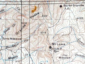
Mt. Lowe/Echo Mountain - 3,207 feet (977 m)
Echo Mountain is a promontory above Altadena, California. It was shaped from an alluvial fan between Rubio and Las Flores canyons. It is geographically defined by Castle Canyon to its leeward side, Rubio Canyon at its foot, and Las Flores Canyon on its windward side. Echo has a mean elevation of 3,250 feet (990 m) above sea level. It is most visible as a short mountain extension whose ridge protrudes below the peak of Inspiration Point. Its name is derived from the number of repetitions one’s voice could emit into Castle Canyon.
Mt. Lukens - 5,030 feet
This is the tallest peak within the LA city limits, and it has spectacular views of the LA basin and surrounding mountains from the summit. This mountain was burned some time ago, so with the exception of the views of the surrounding area, the scenery is rather marginal. The hike to the summit is relentlessly up hill with limited shade along the way.
This is the tallest peak within the LA city limits, and it has spectacular views of the LA basin and surrounding mountains from the summit. This mountain was burned some time ago, so with the exception of the views of the surrounding area, the scenery is rather marginal. The hike to the summit is relentlessly up hill with limited shade along the way.
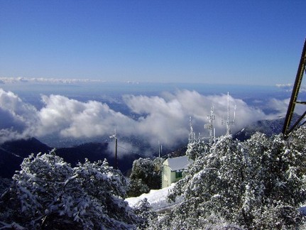
Mt. Wilson - 5,710 ft (1,742 m)
Mount Wilson is one of the more prominent peaks in the San Gabriel Mountains, part of the Angeles National Forest in Los Angeles County, California, USA. It is the location of the Mount Wilson Observatory and has become the astronomical center of Southern California with 60 inch (1524 mm) and 100 inch (2540 mm) telescopes, and 60 foot (18 m) and 150 foot (46 m) solar towers. It is located at 5,710 feet although surrounding peaks around the mountain can rise slightly above 6,000 feet. Due to this elevation, winter snow can sometimes interrupt astronomical activities on the mountain.
Mount Wilson is also referred to as a metro-media center for its relay broadcasting of radio and television frequencies for the Greater Los Angeles Area.
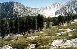
Mt San Jacinto - 10,834 feet
San Jacinto Peak is the highest peak in Riverside County, California. It is part of the San Jacinto Mountains, and lies within Mount San Jacinto State Park. To the east, the peak towers over the city of Palm Springs; to the west, it borders the mountain community of Idyllwild. The peak is also frequently named Mount San Jacinto. The steep escarpment of its north face, above Snow Creek, climbs over 10,000 feet (3 km) in 7 miles (11.3 km). This is one of the largest gains in elevation over such a small horizontal distance in the contiguous United States.
The mountain is quite rugged in places, with several outdoor hazards that hikers may be unprepared for, including high altitude, severe weather, steep rock faces, and wild animals. Hikers and climbers die or are harmed every year.
Mt. Baden - 9,399 feet
Mt. Baden is a peak in the San Gabriel Mountains of California named for the famous English Lord Robert Baden-Powell, founder of the World Scouting Movement. Mount Baden Powell was officially recognized by the USGS at a dedication ceremony in 1931.[1] Its first designation was East Twin or North Baldy named by C. F. Saunders in 1923.
At 9,399 feet (2,865 m) in elevation, Mount Baden-Powell is the 4th highest peak of the San Gabriel Range, Mount San Antonio or “Old Baldy” being the highest at 10,064 feet (3,068 m). The summit has long been a favorite of hiking excursions either from the Mt. Islip Saddle near Little Jimmy Trail Camp, or the Vincent Gap Trail which leads up a moderate to strenuous set of switchbacks from Wrightwood. Mt. Baden-Powell is also the high point along the historic 53 mi (85 km) Boy Scout hiking trail, The Silver Moccasin Trail, that connects to this summit to Mount Burnham (less than a mile (1.6 km) away), Throop Peak and Mount Hawkins.
The Vincent Gap hike leads through a variety of forested areas consisting of Jeffrey pines, ponderosas, lodgepoles, cedars, and an ancient forest of Limber pines, some noted to be as old as 2,000 years.
Cucamonga Peak - 8,859 feet
Cucamonga Peak is one of the highest peaks in the San Gabriel Mountains in the U.S. state of California. It is under the jurisdiction of the San Bernardino National Forest, in the Cucamonga Wilderness area. Named for Tiburcio Tapia’s Cucamonga Rancho of Alta California, the mountain towers over the present-day cities of Rancho Cucamonga, Ontario and Fontana. The peak can be seen west of Cajon Pass, which most Angelenos use to get to Las Vegas. The peak can also be seen on a perfectly clear day from San Jacinto 46 miles (74 km) southeast of the peak.
The most accessible trailhead for hiking Cucamonga Peak is Icehouse Canyon. Forest Service Trail 7W07 leads from here to Icehouse Saddle, from which the Cucamonga Peak Trail (7W04) leads to the summit. This route is 12 miles (19.3 km) round trip, with 4,300 feet (1,300 m) of elevation gain.
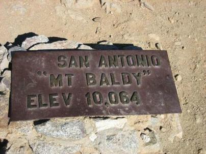
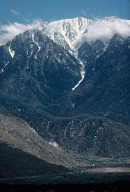
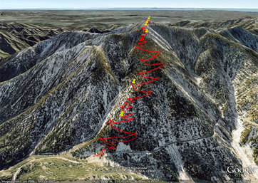
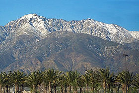
Mt. Baldy - 10,064 feet
Mount San Antonio, better known to most in Los Angeles as Old Baldy or Mount Baldy, is the highest peak in the San Gabriel Mountains of Southern California, USA and the highest point in Los Angeles County. Mount San Antonio has two summits. The eastern summit is higher at an elevation of 10,064 feet while the west is at 9,988 feet. In winter, Mount Baldy’s snow-capped peaks are usually visible on clear days and dominate the view of the Los Angeles skyline.
The peak, which marks a boundary between San Bernardino County and Los Angeles County [1] is called Baldy because of the absence of trees around the summit. The Tongva tribe call the mountain Yoát or Joat, which means snow, and the Mohave call it Avii Kwatiinyam[2].
Mt. Wilson Toll Road - 5,710 ft (1,742 m)
The Mount Wilson Toll Road (1891-1936) is a historic roadway which ascended Mount Wilson via a vehicular passable road from the base of the foothills in Altadena. It was accessible from Pasadena via Santa Anita Avenue which drove right to the front porch of the toll house. The access road is still visible on private property along Altadena Drive in Altadena.
Mount Wilson had always been active with human passage starting from the days of the local Indians. It was Benjamin Davis Wilson who established a proper trail to the summit of Mt. Wilson from Sierra Madre through the Santa Anita Canyon.
**This was my almost daily hike at Sunrise. I still hike this several days a week with my pups. (smile)
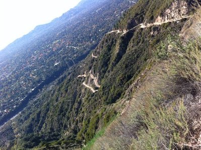
Mt. Baldy from Mt. Baldy Village
This is a must-do hike. I don’t know why anyone would choose another route unless they were going for the 6000’ gain butt kicker from Baldy Village, but that’s a whole different ball game. Don’t take the wimpy ski lift on a Saturday. Take this trail, you wont regret it!
The path is grand, it starts on the road to beautiful San Antonio Falls, and then moves onto a trail that will get your heart pounding the moment you set foot on it. Rapidly you’ll reach the Ski Hut(8200’) and cross the bowl. There are a couple of places where the trail is a little difficult to find, but if you look for the obvious, you should be able to manage.
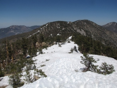
Mt. San Goronio - 11,502 feet
San Gorgonio Mountain (or Mount San Gorgonio, or Old Greyback) is the highest peak in Southern California at 11,502 feet (3,506 m) above sea level. It is located in the San Bernardino Mountains, 27 mi (42 km) east of the city of San Bernardino and 12 mi (19 km) north-northeast of San Gorgonio Pass. It lies in the San Gorgonio Wilderness, part of the San Bernardino National Forest. Spanish missionaries in the area during the early 1800s named the peak after Saint Gorgonius.
Since it is the highest point in a region which is separated from higher peaks (e.g. in the Sierra Nevada) by relatively low terrain, San Gorgonio Mountain is one of the most topographically prominent peaks in the United States. It is ranked 7th among peaks in the contiguous US, and 18th among all US peaks.[1]
Several trails lead to the broad summit of San Gorgonio Mountain, which rises only a few hundred feet (100 m) above the tree line. Any route requires well over 4,000 feet (1,220 m) of elevation gain.
San Bernadeno Peak - 10,691 feet
The San Bernardino Mountains (Huwaaly Kwasakyav[1] in Mojave) are a short transverse mountain range northeast of Los Angeles in Southern California in the United States. The mountains are also located north and east of San Bernardino, California (the nearest big city).The mountains run for approximately 60 mi (100 km) east-west on the southern edge of the Mojave Desert in southwestern San Bernardino County, north of the city of San Bernardino. The range is separated from the San Gabriel Mountains to the west by Cajon Pass, and from the San Jacinto Mountains to the south/southeast by Banning Pass. The southern extent of the range is bounded by the San Andreas Fault.
This trail is a no-nonsense elevation gainer. however, it maintains a steady grade for a large portion of the trip. You begin in a mixed oak/pine forest and briskly head up the side of the ridge. Two miles into the trail you enter the San Gorgonio Wilderness, which is marked by a sign. The trail evens off a bit here, but not too much. You will be climbing and climbing some more. In two more miles you will reach a relatively flat area covered with Manzanita and chaparral. This flat area is your halfway reprieve, and it continues until you reach the trail junction for Columbine Springs and John’s Meadow.
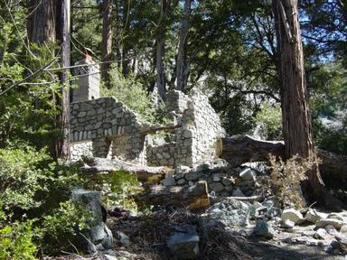
Malibu Creak Backbone Trail
From Malibu Creek you can get to the Backbone Trail, the holy grail of trails in the Santa Monica Mountains. Connecting them is the infamous Bulldog Motorway - you either love it or hate it - as it climbs 1750 feet from the valley floor to the Castro Motorway on Castro Ridge.
This area has a rich history of providing backdrops to distant places for Hollywood, from silent films to the most well-known use, the filming of the movie and TV series M*A*S*H in the 1970’s. Many other shows were made here as well.